22 Day Cape Town, Namibia Safari
Departs from: Cape Town
Ends in: Cape Town
Length: 22 Days
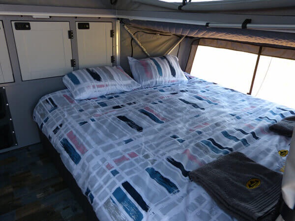
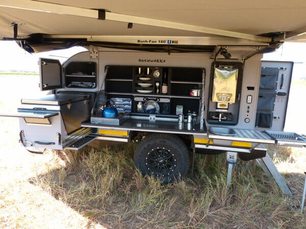
Accommodation: Camping off road caravan
Departure: Contact us for dates
For Bookings & Inquiries
Call Us
WhatsApp Us
Email Us
Day 1 Cape Town to Klawer – A South Africa Safari Tour
Distance approx. 271 Km Driving time approx. 3 hours
For this South Africa Safari Tour, we will collect you from your hotel, accommodation in Cape Town or surroundings between 6 and 7 am in the morning on the day of departure where we will go have breakfast at a wine farm and get to know each other and just go through the trip details. After breakfast we will head out for our first overnight stop at a wine farm just outside Klawer. Klawer is a town in the Matzikama Municipality in the Western Cape province of South Africa. It is situated on the right bank of the Olifants River, 17 kilometres (11 mi) south-east of Vredendal and 240
kilometres (150 mi) north of Cape Town. According to the 2011 census it has a population of 6,234 people in 1,680 households. The name Klawer comes from the Afrikaans word for a type of wild clover which grows here after the rains
Day 2 Klawer to Vioolsdrift
Distance approx. 459 km; driving time approx. 5,30
Here we will staying on the banks of the orange river. Vioolsdrif is a village on the Orange River in the north-western part of South Africa Safari Tour, known as Namaqualand. The name in Afrikaans means ‘the ford (shallow river crossing) of the violin’. It is reportedly named after Jan Viool (“John Violin”), who is said to have played the fiddle in these parts in the nineteenth century. Some say he was a Nama man, who used to guide ox-wagons across the ford. An accomplished player, he would fiddle away merrily on the riverbank while waiting for wagons to arrive. These
claims await elaboration.
Day 3,4 Vioolsdrift to Fish River Canyon (Namibia)
Distance approx. 232 km; Driving time approx. 3 hours
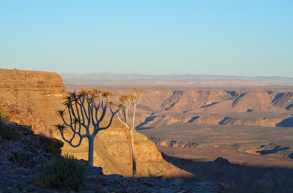
To day we cross the border into Namibia this process should take about 1 hour and we should hopefully be on our way. The Fish River Canyon (Afrikaans: Visrivier Canyon or Visrivier Kuil, German: Fischfluss Canyon), is located in the south of Namibia. It is the largest canyon in Africa, as well as the second most visited tourist attraction in Namibia. It features a gigantic ravine, in total about 100 miles (160 km) long, up to 27 km wide and in places almost 550 meters deep. The Fish River is the longest interior river in Namibia. It cuts deep into the plateau which is today dry, stony and sparsely covered with hardy drought-resistant plants. The river flows intermittently, usually flooding in late summer; the rest of the year it becomes a chain of long narrow pools. At the lower end of the Fish River Canyon, the hot springs resort of Ai-Ais is situated. Public viewpoints are near Hobas, a camp site 70 km north of Ai-Ais. This part of the canyon is part of the Ai-Ais/Richtersveld Transfrontier Park. The other 90 km of this canyon are privately owned.
Day 5 Fish River Canyon to Mariental
Distance approx. 360 km; driving time 3,40 hours
Mariental is a city of 10,000 inhabitants in south-central Namibia, lying on the B1 national road 232 kilometres (144 mi) north of Keetmanshoop and 274 kilometres (170 mi) southeast of Windhoek. It lies at an elevation of 1,090 metres (3,580 ft). Mariental is connected to the TransNamib railway line from Windhoek to Keetmanshoop. The town and the surrounding
area are in a hot, arid region. Mariental is the administrative capital of the Hardap Region in an area which has long been a centre for the Nama people. It lies near the Hardap Dam, the largest reservoir in Namibia. Named by local Rhenish (German Lutheran) missionaries, the town was founded in 1912 as a railway stop between Windhoek and Keetmanshoop and named after Maria, the wife of the first colonial settler of the area, Hermann Brandt. It was proclaimed a town in 1920 and a municipality in 1946. Mariental is home to a large number of Nama-speaking people, descendants of the early Khoi inhabitants of Namibia. The people of Mariental are known for their big smiles and hospitality.
Day 6,7 Mariental to Windhoek
Distance approx. 266 km; driving time 2,3 hours
Windhoek is the capital and largest city of the Republic of Namibia. It is located in central Namibia in the Khomas Highland plateau area, at around 1,700 metres (5,600 ft) above sea level, almost exactly at the country’s geographical centre. The population of Windhoek in 2011 was 325,858, growing continually due to an influx from all over Namibia. The city developed at the site of a permanent hot spring known to the indigenous pastoral communities. It developed rapidly after Jonker Afrikaner, Captain of the Orlam, settled here in 1840 and built a stone church for his community. In the decades following, multiple wars and armed hostilities resulted in the neglect and destruction of the new settlement. Windhoek was founded a second time in 1890 by Imperial German Army Major Curt von François, when the territory was colonised by the German Empire. Windhoek is the social, economic, political, and cultural centre of the country. Nearly every Namibian national enterprise, governmental body, educational and cultural institution is headquartered there.
Day 8,9,10,11 Windhoek to Etosha National Park
Distance approx. 544 km; driving time approx. 6 hours
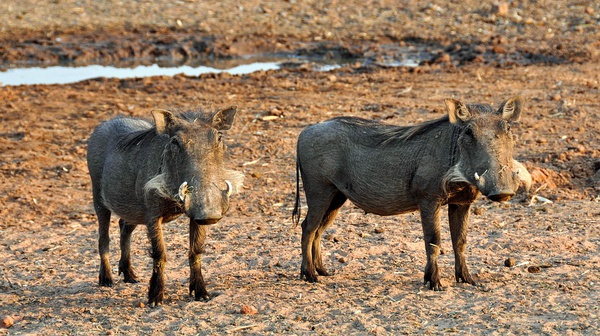
Here we will explore the aria with daily game drives going out to look for the big 5. Etosha National Park is a national park in northwestern Namibia. It was proclaimed a game reserve in March 1907 in Ordinance 88 by the Governor of German South West Africa, Dr. Friedrich von Lindequist. It was designated as Wildschutzgebiet in 1958, and was elevated to the status of a national park in 1967 by an act of parliament of the Republic of South Africa. It spans an area of 22,270 km (8,600 sq mi) and gets its name from the large Etosha pan which is almost entirely
within the park. The Etosha pan (4,760 km (1,840 sq mi)) covers 23% of the area of the total area of the Etosha National Park. The park is home to hundreds of species of mammals, birds and reptiles, including several threatened and endangered species such as the black rhinoceros. The park is located in the Kunene region and shares boundaries with the regions of Oshana, Oshikoto and Otjozondjupa.
Day 12 Etosha National Park to Okahandja
Distance approx. 404 km; driving time approx. 4,20 hours
Okahandja is a city of 24,100 inhabitants in Otjozondjupa Region, central Namibia, and the district capital of the Okahandja electoral constituency. It is known as the Garden Town of Namibia. It is located 70 km north of Windhoek on the B1 road. It was founded around 1800, by two local groups, the Herero and the Nama. Okahandja means the place where two rivers flow into each other to form one wide one in Otjiherero
Day 13,14,15 Okahandja to Swakopmund
Distance approx. 313 km; driving time approx. 3 hours
We will spend 3 night in Swakopmund as there is much to do and see in the aria, we have also arranged for you to go on a living desert tour. Swakopmund (German for “Mouth of the Swakop”) is a city on the coast of North-western Namibia, 280 km (170 miles) West of Windhoek,
Namibia’s capital. Swakopmund is the capital of the Erongo administrative district. The town has 42,000 inhabitants and covers 193 square kilometres (75 sq mi) of land. The city is situated in the Namib desert. Swakopmund is a beach resort and an example of German colonial architecture. It was founded in 1892 as the main harbour for German South-West Africa, and a sizable part of its population is still German speaking today. The city lies on the B2 road and the Trans-Namib Railway from Windhoek to Walvis Bay. It is also home to Swakopmund Airport and Swakopmund Skydiving Club. Buildings in the city include the Altes Gefängnis prison, designed by Heinrich Bause in 1909. The Woermannhaus, built in 1906 with a prominent tower, is now a public library.
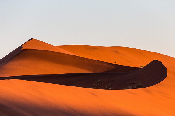
Day 16,17 Swakopmund to Sossusvli
Distance approx. 347 Km Driving time approx. 5 hours
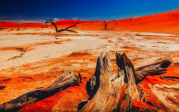
Here we have a great camp site in the Namib dessert where we will spend the next 2 nights from here there are a number of wonderful attractions to be enjoyed around Sossusvlei in the largest conservation area in Namibia, the Namib-Nakluft National Park, which covers almost
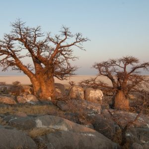
50,000 km2. The top attraction of the park and the second most popular attraction in Namibia, Sossusvlei is renowned for its majestic, warm red, starshaped dunes contrasting against the stark white floors of the pans. Other attractions in close proximity to Sossusvlei include Sesriem Canyon, Dune 45, Hiddenvlei, Big Daddy and Deadvlei. All of these attractions can be accessed from the road that takes you to Sossusvlei and are all well worth a visit. In a number of areas surrounding Sossuvlei look out for the petrified dunes. These are ancient dunes that are approximately 1 billion years old and have solidified into rock.
Day 18,19 Sossusvli to Aus
Distance approx. 345 Km Driving time 5 hours
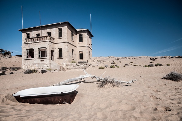
This is where in this South Africa Safari Tour, we will spend our last 2 nights in Namibia from where we will visit the small town of Luderitz and also visit the old ghost town of kolmanskop with its very interesting history This tranquil little desert town is situated 125km east of Luderitz and the name means ‘out’ in
German but may be derived from a Khoi-Khoi word which means the ‘place of the snakes’.Aus is tucked between the folds of several hills, and if you’ve ventured this far, then the chances are you’re on the way to the coast. After the German surrender to South African troops in World
War I, Aus became an internment camp for German military officers. As many as 1,550 prisoners were held at Aus, and the town’s population was further boosted by around 600 South African guards. The railway to Luderitz stops here, as some years ago the continual struggle to keep the line clear of the Namib Desert sand was abandoned, and in places the line is now covered by massive dunes. One of the major attractions of the area around Aus is the Namib Feral Horses. They are the world’s only wild desert-dwelling horses and theories as to their origin are many. A logical favourite is that they were descended from German Schutztruppe
cavalry horses abandoned during the South African invasion of 1915. Another is that they were brought by Nama raiders moving north from beyond the Orange River, whilst a third claims they’re descended from a load of ship-wrecked horses en-route from Europe to Australia. More local (and believable), is the story they’ve been bred from the stud stock of Baron Captain Hans-Heinrich von Wolf, the owner of Duwisib Castle
Day 20 Aus to Vioolsdrift South Africa
Distance approx. 348 Km Driving time 5 hours
Here we will be crossing the border back into South Africa and staying on the banks of the orange river. Vioolsdrif is a village on the Orange River in the north-western part of South Africa, known as Namaqualand. The name in Afrikaans means ‘the ford (shallow river crossing) of the violin’. It is reportedly named after Jan Viool (“John Violin”), who is said to have played the fiddle in these parts in the nineteenth century. Some say he was a Nama man, who used to guide ox-wagons across the ford. An accomplished player, he would fiddle away merrily on the riverbank while waiting for wagons to arrive. These claims await elaboration.
Day 21 Vioolsdrift to Klawer
Distance approx. 433 km; Driving time approx. 4,2 hours
This is our final night on tour where we will stay camp over on a working wine farm enjoy a good meal together and look back on the trip over a glass of wine or 3. Klawer is a town in the Matzikama Municipality in the Western Cape province of South Africa. It is situated on the right bank of the Olifants River, 17 kilometres (11 mi) south-east of Vredendal and 240
Day 22 Klawer to Cape Town
Distance approx. 271 km; driving time approx. 3 hours
After a sleep in and breakfast, we will head back to Cape Town at the end of this South Africa Safari Tour, where you will be dropped at Cape Town International Airport or Cape Town surrounding place of your choice
What’s Included
Registered guide fluent in English and German
All camping, park and safari fees as per itinerary
Breakfast and dinner daily
Selected beverages
All transport in a fully equipped 4×4 vehicle
Accommodation in an off-road caravan with double bed
Bedding and towels
Game drives
Fuel
Activities as per itinerary
What’s Excluded
All flights and visas and border fees
Personal & medical insurance
Personal belongings
Tips, curios and any optional excursions and activities
Passports
Vaccinations
Visas
Join our mailing list