22 Day Cape Town, Botswana, Namibia, Victoria Falls Safari
Departs from: Cape Town
Ends in: Cape Town
Length: 21 Days
Accommodation: Camping off road caravan
Departure: Contact us for dates
For Bookings & Inquiries
Call Us
WhatsApp Us
Email Us
Day 1 Cape Town to Three Sisters
Distance approx. 536 km; driving time approx. 6 hours
We will collect you from your hotel, accommodation in Cape Town or surroundings between 6 and 7 am in the morning on the day of departure where we will go have breakfast at a wine farm and get to know each other and just go through the trip details. After breakfast around 10 am we will depart for Three Sisters this will be our first night stop. The Three Sisters are a land formation near Victoria West, Northern Cape, comprising three distinctively shaped hills. The hills (or “koppies” as they are known locally) are topped with dolorite, and are nearly identical in appearance. They can be seen just to the east of the N1 highway, roughly 75 kilometres outside Beaufort West, north of the junction of the N1 and the N12 highways. Due to the open and mountainous Karoo scenery, the area has become a relatively well-known landmark. You will be happy you booked this one out of all our African Safari packages
Day 2 Three Sisters to Douglas
Distance approx. 385 km; driving time approx. 4 hours
After a hearty South African breakfast, we take a leisurely drive to our nest destination a small-town Douglas. Douglas is an agricultural and stock farming town situated near the confluence of the Orange and Vaal Rivers in the Northern Cape province of South Africa. Notably the rural town has a diverse population, with mostly state institutions and the anchor private employer, GWK, an agricultural company. Douglas lies about 100km southwest of Kimberley the capital of the Northern Cape. These two are connected by the R357 road. The town was founded in 1848 as a mission station on the farm Backhouse by the Reverend Isaac Hughes[2], who had been working along the Vaal River since 1845. In 1867, a group of Europeans from Griquatown signed an agreement giving them the right to establish a town. The town was named after General Sir Percy Douglas, Lieutenant Governor of the Cape Colony.
Day 3 Douglas to Mokolodi Nature Reserve (Botswana)
Distance approx. 644 Km Driving time approx. 7 hours
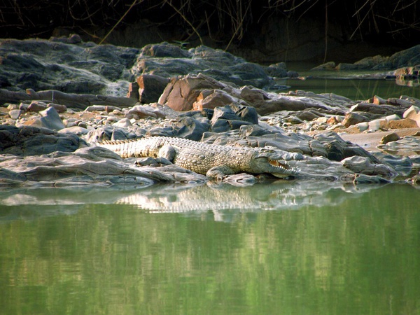
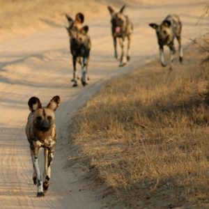
After breakfast at a round 6am we will depart for Mokolodi in Botswana we will cross the border at the Ramatlabama border post this should take approx. 1 hour once we have reached our destination after checking in your guide will set up camp where you can relax and listen to nature.The creation of the Mokolodi Wildlife Foundation lead to the establishment of the Mokolodi Nature Reserve in 1994 on 3,700 hectares of donated bushveld land that had previously been utilised for cattle farming. The Reserve is now home to a wide variety of animals and plants that are endemic to south-eastern Botswana, some of which are extremely rare or endangered. Since its creation, Mokolodi Nature Reserve and its programmes have grown significantly. The Reserve currently employs approximately 90 people, of which approximately 75 are from neighbouring communities. Our Education Centre accommodates more than 9,000 school children per year in its environmental education programmes, and the Reserve on a whole welcomes more than 60,000 visitors on an annual basis. We love taking our clients on these trips in our African Safari packages.
Day 4 Mokolodi to Kharma Rhino Sanctuary
Distance approx. 336 Km Driving time 4 hours
After breakfast, we will make a short stop in Gaborone the capital city of Botswana to stock up our fridges for the next few day from there we will head up the A1 road towards the town of Palapye not far from our next stop over that we should reach at around 3pm after checking in and setting up camp we will take a game drive and hopefully see some Rhino where we will return back to camp just before sunset. The Khama Rhino Sanctuary (KRS) is a community based wildlife project, established in 1992 to assist in saving the vanishing rhinoceros, restore an area formerly teeming with wildlife to its previous natural state and provide economic benefits to the local Botswana community through tourism and the sustainable use of natural resources. Covering approximately, 8585 hectares of Kalahari Sandveld, the sanctuary provides prime habitat for white and black rhino as well as over 30 other animal species and more than 230 species of birds.
Day 5 Kharma Rhino Sanctuary to Elephant Sands
Distance approx. 484 Km Driving time approx. 6 hours
After breakfast, we will look at getting an early start here as we would like to get to our next destination in good time so that we may get a camp site right in front of the water hole where you can relax in the comfort of your camp and watch the elephants dinner will be around the camp fire prepared by your guide. Elephant Sands is a bush lodge & campsite in the northeastern part of Botswana. Come and enjoy viewing the elephants at our natural waterhole right in front of the lodge. Watch these impressive creatures whilst they drink at only a couple of meters away from you, a unique experience. There is plenty of other wildlife around as well on our unfenced 16000 ha private conservancy. The lack of fences allows all animals to roam freely.
Day 6,7 Elephant Sands to Senyati Safari Camp
Distance 248 Km Driving time 3 hours
On this day, you can sleep in a bit if you are not woken up by the elephants as we have a short drive to our next camp that is about 20km outside of Kasane where we will spend the next 2 nights after checking in you will be transported to Kasane where you will go on a 3 hour sunset cruse on the Chobe River once your cruse is done you will be collected from the boat and taken back to your camp where you will have a dinner in the lodge. The following day after breakfast you will be collected to go on a full day tour of Victoria Falls including lunch you will return to camp in the late afternoon where you can relax around the swimming pool at the lodge. Senyati Safari Camp is situated in the Lesama valley Northman Botswana. Although Senyati is very private the waterhole knows no privacy. A variety of animals come and go throughout the day. The waterhole is frequented by a variety of species such as hyena, banded mongoose, warthogs, roan antelope, monkeys, baboons, buffalo, sable, elephants and the occasional leopard
Day 8,9,10 Senyati Safari Camp to Ihaha Camp Chobe National Park
Distance approx. 65 Km Driving time approx. 1 hour
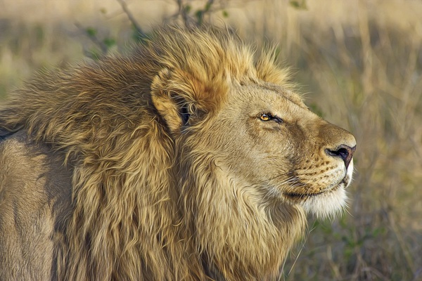
After breakfast, we will take the short trip to Ihaha Camp. This is where you will get the true African wild camping adventure feeling as we will be camping on the banks of the Chobe River with free wild roaming animals after setting up camp we will just sit back relax and take in the scenery as we have 3 nights hear from where we will take daily game drives in the mornings. Proclaimed a wildlife reserve in 1968, and covering 11,700km2, Chobe National Park is situated in the far north-east of Botswana, bordered to the north by the Chobe River. Chobe is game viewing country, particularly in winter (March – July). November – December sees the migration of herbivores between the Chobe River and Savuti Marsh (and back between February and April). Game-viewing and bird-watching cruises on the Chobe River. The Chobe’s perennial waters rise in the northern Angolan highlands. Chobe has four physically and vegetation ally distinctive areas; the barely discernible dry Savuti Channel, Linyati, Serondella and Nogatsaa. Each area known for concentrations of specific game. Savuti famous for lion and hyaena, Linyati for hippo and crocodile, and Nogatsaa and Serondella for elephant. Savuti’s carnivores follow large herds of zebra, wildebeest, buffalo and impala that move through the area. Many types of animals seen including the rare puku and Chobe bushbuck. 460 bird species, including raptors, vultures and inland water birds.
Day 11 Ihaha Camp Chobe National Park to Popa Falls Namibia
Distance approx. 412 Km Driving time 5 hours
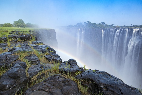
Here we will have our second border crossing this time in to Namibia at the Ngoma border post we will leave early in the morning after sun rise as we will have many photo opportunities along this rout again and we can make a few stops to explore on the way ones we reach Popa Falls we will check in here we will spend the night in a real bed again so that we can recuperate from ruffing it the last few days here you will also be able to spend the time as you like as your guide will be doing a few maintenance checks on the equipment. Popa Falls Resort is a gateway to the north-eastern corner of Namibia and home to perennial rivers, magnificent indigenous woodlands, riverine forests, floodplains and reedlined channels. The resort is located on the Kavango River, and the falls are accessible by foot from here. The falls, in fact, are not falls as
one may expect from its name. Instead, they are a series of cascades created naturally over time by the running river, which splits the rock and forms a vast network of river channels.
Day 12 Popa Falls Namibia to Otavi Namibia
Distance approx. 557 Km Driving time approx. 6 hours
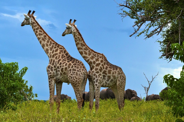
We will leave early in the morning with the sun rise so that we can get to our next destination in good time so that we can laze around the swimming pool and sip on cocktails. A game drive has also been organised here for you to travel in one of their open game vehicles. Gabus Game Ranch is a 6200-hectare game lodge in Namibia situated only 8km from the B1 main road passing through Otavi, Namibia. The beautiful mountains and savannah-grasslands are home to a big
number of wildlife including Giraffe, Zebra, Waterbuck, Eland, Leopard, Cheetah to mention a few species.
Day 13,14,15 Otavi to Swakopmund
Distance approx. 511 Km Driving time approx. 6 hours
we will spend 3 night in Swakopmund as there is much to do and see in the aria, we have also arranged for you to go on a living desert tour. Swakopmund (German for “Mouth of the Swakop”) is a city on the coast of North-western Namibia, 280 km (170 miles) West of Windhoek, Namibia’s capital. Swakopmund is the capital of the Erongo dministrative district. The town has 42,000 inhabitants and covers 193 square kilometres (75 sq mi) of land. The city is situated in the Namib desert. Swakopmund is a beach resort and an example of German colonial architecture. It was founded in 1892 as the main harbour for German South-West Africa, and a sizable part of its population is still German speaking today. The city lies on the B2 road and the Trans-Namib Railway from Windhoek to Walvis Bay. It is also home to Swakopmund Airport and Swakopmund Skydiving Club. Buildings in the city include the Altes Gefängnis prison, designed by Heinrich Bause in 1909. The Woermannhaus, built in 1906 with a prominent tower, is now a public library. Its important to visit these landmarks in our African Safari packages.
Day 16,17 Swakopmund to Sossusvli
Distance approx. 347 Km Driving time approx. 5 hours
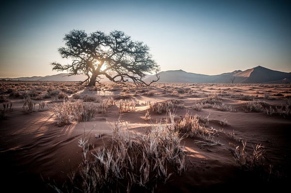
Here we have a great camp site in the Namib dessert where we will spend the next 2 nights from here there are a number of wonderful attractions to be enjoyed around Sossusvlei in the largest conservation area in Namibia, the Namib-Nakluft National Park, which covers almost 50,000 km2. The top attraction of the park and the second most popular attraction in Namibia, Sossusvlei is renowned for its majestic, warm red, starshaped dunes contrasting against the stark white floors of the pans. Other attractions in close proximity to Sossusvlei include Sesriem Canyon, Dune 45, Hiddenvlei, Big Daddy and Deadvlei. All of these attractions can be accessed from the road that takes you to Sossusvlei and are all well worth a visit. In a number of areas surrounding Sossuvlei look out for the petrified dunes. These are ancient dunes that are approximately 1 billion years old and have solidified into rock.
Day 18,19 Sossusvli to Aus
Distance approx. 345 Km Driving time 5 hours
This is where we will spend our last 2 nights in Namibia from where we will visit the small town of Luderitz and also visit the old ghost town of kolmanskop with its very interesting history This tranquil little desert town is situated 125km east of Luderitz and the name means ‘out’ in German but may be derived from a Khoi-Khoi word which means the ‘place of the snakes’.Aus is tucked between the folds of several hills, and if you’ve ventured this far, then the chances are you’re on the way to the coast. After the German surrender to South African troops in World War I, Aus became an internment camp for German military officers. As many as 1,550 prisoners were held at Aus, and the town’s population was further boosted by around 600 South African guards. The railway to Luderitz stops here, as some years ago the continual struggle to keep the line clear of the Namib Desert sand was abandoned, and in places the line is now covered by massive dunes. One of the major attractions of the area around Aus is the Namib Feral Horses. They are the world’s only wild desert-dwelling horses and theories as to their origin are many. A logical favourite is that they were descended from German Schutztruppe cavalry horses abandoned during the South African invasion of 1915. Another is that they were brought by Nama raiders moving north from beyond the Orange River, whilst a third claims they’re descended from a load of ship-wrecked horses en-route from Europe to Australia. More local (and believable), is the story they’ve been bred from the stud stock of Baron Captain Hans-Heinrich von Wolf, the owner of Duwisib Castle
Day 20 Aus to Vioolsdrift South Africa
Distance approx. 348 Km Driving time 5 hours
Here we will be crossing the border back into South Africa and staying on the banks of the orange river. Vioolsdrif is a village on the Orange River in the north-western part of South Africa, known as Namaqualand. The name in Afrikaans means ‘the ford (shallow river crossing) of the violin’. It is reportedly named after Jan Viool (“John Violin”), who is said to have played the fiddle in these parts in the nineteenth century. Some say he was a Nama man, who used to guide ox-wagons across the ford. An accomplished player, he would fiddle away merrily on the riverbank while waiting for wagons to arrive. These claims await elaboration, but we enjoy telling these stories in all our African Safari packages.
Day 21 Vioolsdrift to Klawer
Distance approx. 433 km; Driving time approx. 4,2 hours
This is our final night on tour where we will stay camp over on a working wine farm enjoy a good meal together and look back on the trip over a glass of wine or 3. Klawer is a town in the Matzikama Municipality in the Western Cape province of South Africa. It is situated on the right bank of the Olifants River, 17 kilometres (11 mi) south-east of Vredendal and 240 kilometres (150 mi) north of Cape Town. According to the 2011 census it has a population of 6,234 people in 1,680 households.[1] Then name Klawer comes from the Afrikaans word for a type of wild clover which grows here after the rains
Day 22 Klawer to Cape Town
Distance approx. 271 km; driving time approx. 3 hours
After a sleep in and breakfast, we will head back to Cape Town where you will be dropped at Cape Town International Airport or Cape Town surrounding place of your choice. We are certain you would have enjoyed our African Safari packages.
What’s Included
Registered guide fluent in English and German
All camping, park and safari fees as per itinerary
Breakfast and dinner daily
Selected beverages
All transport in a fully equipped 4×4 vehicle
Accommodation in an off-road caravan with double bed
Bedding and towels
Game drives
Fuel
Activities as per itinerary
Expert African Safari packages
What’s Excluded
All flights and visas and border fees
Personal & medical insurance
Personal belongings
Tips, curios and any optional excursions and activities
Passports
Vaccinations
Visas
Visit our our related products for our other African Safari packages
Join our mailing list